
Perils of flying over the hump route : Â Sky way to hell
By
Colonel Satish Singh Lalotra
“The propeller is just a big fan in front of the plane used to keep the pilot cool. When it stops you can actually watch the pilot start sweating” (A US Air Force pilot in 2. world war on flying the hump route)
The quote above of a US Air force pilot summarizes the cynicism which had crept into most of the force operating on this ill-fated “Hump route “in NEFA(Arunachal Pradesh) during the airlift operation that crossed the Himalayan frontiers into China during the 2 World war. Welcome to one of the most dangerous aerial routes in the world which a pilot faced during that period and even today which gives shivers down the spine to the best of flying aces.But why the word Hump and how did it come to be saying so, If one casts his eye on the present day Arunachal Pradesh’s map and scans the eastern and middle portion of the state he will find that the Indian boundary marks a perceptible rise / hump /raised portion before sloping down the Myanmar/ Chinese border. This raised portion and sloping border resembles a hump like structure and hence the name. My interest in penning down this article stems from the fact that I was posted at a place known as Menchuka while in service in the early 1990s, which forms part of “Greater hump area” of Arunachal Pradesh and considered as a “No Go” area a few years back. Part of Shi-Yomi district, Menchuka is situated in a dense forested valley surrounded by thorn bushes and pine trees. Till a few years back it was an air maintained post of the Indian army, recently connected by a road axis
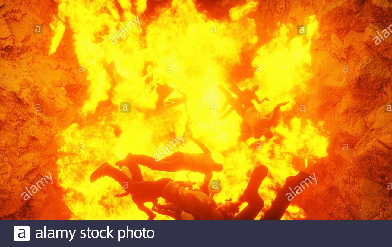
The Hump area starting from Diphu passes till Yaja in Arunachal Pradesh is considered as one of the most hazardous flying areas by the IAF as well as the civil aviation sector. The reasons for it are not far to seek which I shall try covering in detail later in this write up. The area assumes strategic importance being at the trijunction of India, China and Myanmar as also when seen in the light of the latest standoff between the two behemoths at the LAC since early May this year. Before that a rundown of information regarding the background of the infamous Hump aerial route and its ever increasing propensity to remain in the national and international news owing to its notorious properties of weather, topography and its location. The Hump was the nick name given by the allied pilots to this area while overflying the sector during their air lift operations across the mighty Himalayan ranges into China to support the Nationalistic forces of Chiang Kai Sheik against the Japanese invasion during the 2 World war. A special transmission used to emanate from the cockpits of these allied aircrafts “Over the Hump” when they used to cross over to China/Myanmar. The Hump aerial route was notorious can be made out by the fact that more than 600 odd American planes went missing or crashed along with 1000 men or more perished in them while attempting to either return back to base or attempting to cross over to China. The famous US Defense secretary Robert McNamara of the 60s and 70s was one of the few lucky pilots for having flown as a transport pilot during these air lift operations and having survived to tell his part of story in the famous movie, “Fog of War”.Due to the number of aircraft which crashed on this route, it earned another moniker ‘ Sky way to Hell /Aluminum trail .
A brief rundown of the difficulties on this hump route is necessitated over here to put the reader in the right frame to appreciate the humongous effort put in by the pilots to overcome these and sends shivers down the spine even today of best flying aces on this stretch. The foot hills of Himalayas rise more than 15000 /Fifteen thousand feet from the upper Assam plains in a mere short distance of few kilometers touching Arunachal Pradesh , which gives pilots a very tight leeway after taking off from upper Assam in maneuvering their aircrafts to a desired height and angle. The mountains of Arunachal Pradesh cause extreme jet stream strength winds as also dangerous down drafts at extreme altitudes. The transport pilots often plod at about 250 to 300 miles per hour, while the winds lift their planes to more than 25, 000 feet and then back to 7000 feet shortly thereafter. If the pilots aren’t fighting their nerves then they would surely be fighting the ice storms and thunderstorms. As an example during the 2 World War , the pilots had to traverse and fly over the Kali Gandki river gorge depression much wider and deeper than the Great canyon of US . Although the Chinese national aviation corporation (CNAC) ran through the route before the war, and its pilots continued to run cargo over the Hump, the army pilots were not all that experienced when this great air lift began.
Cut to the present times ,the Hump aerial route assumes importance all the more, since it is this aerial route which the present day pilots of IAF would have to embark upon taking off from the air bases in upper Assam located at Tezpur, Jorhat, Chabua ,Mohanbarietc for going on their missions in southern Tibet/ Yunan province during active hostilities. The main hurdles facing the pilots during the 2 WW and even today are westerly winds, which could reach about 100 miles per hour, with the weather at its worst from February to April with fierce thunder storms and heavy icing. May to September the weather on this aerial route is typical monsoons heavy with CB/Cumulonimbus clouds and with thunder/lightning raging along side. October to January bring some relief and stability in the weather conditions here when things are smooth for flying. Readers will well remember that in June last year /2019, an AN 32 transport aircraft of the IAF went missing on 03 June 2019 after taking off from Jorhat airbase for Menchuka forward landing ground. The aircraft on a routine supply maintenance task crashed at about 16 kms north of Lipo and NE of Tato village at an altitude of about 12000 feet presumably due to bad weather conditions obtaining due to monsoons.Similarly in April last year, a US B-24 Bomber aircraft’s wreckage was spotted by an army patrol at a place called as Roing in Arunachal Pradesh. It too had probably crashed due to bad weather while returning to base from China during the 2INW. Suffice it to say that the Hump aerial route emanating from Arunachal Pradesh is one of the most hazardous aerial routes, made much more dangerous by the fact that Arunachal Pradesh is one of those states which has minimum road connectivity in India, ultimately pitching the above option as the only one for the routine transportation of locals in areas like Roing, Menchuka, Tuting etc.
Furthermore, the very fact that lateral road connectivity, the dire need of the hour for this frontline state still a pipe dream aggravates the problem further. The much touted Arunachal frontier highway connecting MagoThingbu—Vijaynagar envisaging a total distance of about 2000 kmsstuck in bureaucratic wrangling for its completion casts an ominous shadow on road travel by the locals.The recent abduction of five youths by the Chinese troops from Arunachal Pradesh, upper Subansiri district on 04. of September 2020 has once again shifted the focus on the underdeveloped infrastructure in the border area. Leading state organisations have appealed to the center for its express intervention with China for their early release. It takes about 13 hours to reach Daporijo from the state capital Itanagar ,a distance of around 350 kms and another six hours from Daporijo to reach the Nacho circle ,around 120 kms away from where the suspected kidnapping took place . Apart from this the road from Limeking to Tasking a distance of around 75 kms bordering China is still under construction and yet to be completed even after a passage of 20 years. The road is a central government project but mired in corruption and mal practices. The biggest problem is that of local influence of Arunachali people who are mired in tribal politics and have a parochial approach towards development. One of my colleagues when in army, Anupam Jain a flyer who is now with the Global Vectra and doing routine sorties in this area has been very critical of the slow pace of construction activities and says there are still vast areas in Arunachal Pradesh which are out of reach of humanity. This places a much more reliance on aerial routes as a savior for its population, where in on amenity basis the IAF as also the civil aviation sector transport the locals from place A to B.
The aerial Hump route is significant when seen in the light of the fact that China calls Arunachal Pradesh as South Tibet and lays claim over the entire area. With the present standoff between the PLA of China and Indian army entering its 5th month and no let up in the tensions between both countries on the border dispute, our security establishment is on its toes to ramp up the infrastructure requirements of the frontier areas of the country to meet up the challenge thrown by our northern neighbor. As a consequence of the above development I am sure the weather and its related adjuncts having an effect on air operations have been factored in this vital sector of our country.This observation of mine comes with a caveat since certain data /information from the OSINT /Open source intelligence points to the fact that China is well on its way to massively fortify its air defense capabilities in this sector. It has already installed a very high resolution radar base at Ruili county in Yunan province adjoining Myanmar with its radar sweep covering all our major airbases like Tezpur, Jorhatetc 24×7. This radar base was as a consequence to the Doklam crisis in 2017, and put into action in March 2018.
Alongside the radar base is a missile base of China which recently has sprung up. This radar base at Ruili County is just about 3 kms from the Myanmar international boundary and keeps the much infamous Hump route under its radar sweep too, thus precluding any Indian attempt to preempt the Chinese threat. As per the OSINT the Chinese are particularly keeping a close watch on the Tezpur air base of ours. The elevation profile of the new radar (Type 609) shows that anything which goes up more than 2.5 kms in the sky from Indian side will be picked up. Having flown many times over from upper Assam to Menchuka crisscrossing the Hump aerial route while in serving in 1994/95 with the SFF/Est 22 saw me scared to my bones. With the weather playing truant with the pilots Jesting all the skills ,patience and fortitude at their command all I can say is that the Hump route still retains its sobriquet Sky way to hell” so well coined by the USAF pilots in 2 WW for enduring this treacherous route day in and out . In order to reduce a high reliance on the air freighting of men, material and assorted supplies in this remote corner of our country the Modi government should double quick the pace set for construction of border roads in Arunachal Pradesh lest we are again caught napping as in 1962.
